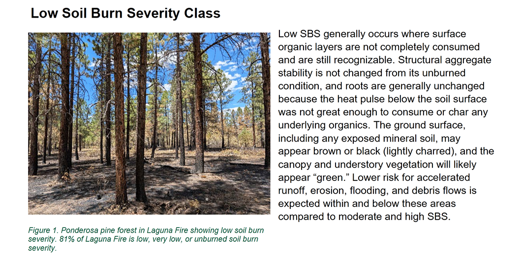
 Ponderosa pine forest in Laguna Wildfire showing low soil burn severity, with 81 percent low, very low, or unburned soil burn severity. Low soil burn severity (SBS) generally occurs where surface organic layers are not completely consumed and are still recognizable. Structural aggregate stability is not changed from its unburned condition, and roots are generally unchanged because the heat pulse below the soil surface was not great enough to consume or char any underlying organics. The ground surface, including any exposed mineral soil, may appear brown or black (lightly charred), and the canopy and understory vegetation will likely appear ‘green’. Lower risk for accelerated runoff, erosion, flooding, and debris flows is expected within and below these areas compared to moderate and high SBS. Courtesy/USFS
Forest Service News:
SANTA FE — A Burned Area Emergency Response (BAER) team has created the soil burn severity map for the Laguna Wildfire that shows an estimate of fire effects on soils. Approximately 81 percent of the Laguna Fire acres are either unburned/very low or low soil burn severity, while 14 percent sustained moderate and 5 percent were identified as high.
This mosaic pattern, dominated by low soil burn severity, is consistent with the natural effects of fire in ponderosa pine and mixed conifer forests in northern New Mexico.
The soil burn severity map analyzes 17,494 acres that burned in the Laguna Wildfire, started by lightning June 25, 2025, on the Coyote District.
The BAER team used preliminary remote sensing satellite imagery with field-validated data collected over multiple days to produce the Soil Burn Severity map. Changes in soil cover, water repellency, and soil physical and biological conditions guide the interpretations of remote sensing imagery to determine the severity of effects on soil caused by exposure to fire.
The BAER team is now using the soil burn severity map and other field observations to analyze the risk of post-fire impacts on critical values to determine the need for emergency actions on National Forest System lands. Additional details will be shared when the risk analysis is completed.
The Laguna Wildfire soil burn severity map can be downloaded as a pdf file in the “Maps” tab at https://inciweb.wildfire.gov/incident-information/nmsnf-laguna-wildfire. Updated information about the Laguna Wildfire operations, soil burn severity, other maps, closure information, and the BAER effort is provided at the same site.
The lightning-sparked Laguna Wildfire began June 25, in the Coyote Ranger District. Initial efforts focused on assessing conditions and preparing containment lines. Over the following days, strategic firing operations were used to manage fire spread across forested areas with prior fire history. On July 12, intense downdraft winds caused the fire to escape containment near Laguna Peak, prompting an aggressive full suppression response. Firefighters contained the spot fire using hotshot crews, helicopters, and aerial resources. On July 14, command of the Laguna Wildfire transitioned to Southwest Area Incident Management Team 1, who had command of the fire until July 29, when command was transferred back to the SFNF Type 4 team. Closure Order 03-10-01-25-08 remains in effect to ensure public safety during ongoing fire operations.
Public Safety Advisory: The fire suppression operation is continuing, a public safety closure order is still in effect, and the summer monsoons can create hazards extending beyond the fire area. Everyone near and downstream from the burned area should remain alert and stay updated on weather conditions that may result in heavy rains and increased water runoff. Flash flooding may occur quickly during heavy rain events-be prepared to act. Current weather and emergency notifications can be found at the National Weather Service website: www.weather.gov/abq/.
Understanding Soil Burn Severity Classes