
 Open Views: When visiting the Flaming Gorge area, traveling from south to north, one would be on Utah Highway 44 to drive the Sheep Creek Geological Area. This view was taken a short distance into the 13-mile loop that traverses through high meadows and open spaces surrounded by mountains. The views are tremendous and there are some areas along the loop road to stop and appreciate the landscape. Photo by Gary Warren/ladailypost.com
 Forested Hillsides: The loop road passes through mountains and high desert terrain for the first few miles of the loop. Many views such as this forested hillside broken up by rocky formations can be seen during this portion of the journey before entering the Sheep Creek geological side of the loop. Photo by Gary Warren/ladailypost.com
By GARY WARREN
Photographer
Formerly of Los Alamos
When visiting the Flaming Gorge National Recreation Area in Utah recently, we wanted to drive the Sheep Canyon Geological Loop. This is an area just to the west of Flaming Gorge Reservoir, which is considered a “must-see” destination when in the area.
The loop is a short 13-mile drive near Manila, Utah and the Wyoming border, which leads visitors through the geological beauty and diversity of the Utah landscape. The drive offers stunning geological formations and breathtaking landscapes during the short drive.
The geological magic that is revealed during the drive gives visitors an opportunity to see millions of years of geological activity. Jagged ridges of multiple colors with tilted, twisted and folded rocks are seen on canyon walls that were formed millions of years ago, making up the Sheep Creek Canyon Geological Area.
This geological activity creating these formations, is the Uinta Crest Fault in the northern Uinta Mountains in northeastern Utah. The Sheep Creek Canyon overlook on the loop road is a must-stop. From this viewpoint one can see red rock formations from 770 million years ago, which sit next to a lighter grayish color Deseret Limestone cliff formation that is a mere 300 million years old. The limestone cliffs are known as The Palisades.
Descending from the overlook viewpoint, drivers enter Sheep Creek Canyon. Canyon walls sit near each other giving space for the roadway, Sheep Creek and some foliage along the canyon floor for the next few miles. The views are spectacular as you drive through the canyon and peer upwards at the canyon walls. The formation that stands out during this portion of the drive is the Tower Rock. This towering formation is Weber sandstone, which stands as a tower detached from the cliffside wall of the canyon.
This short drive is an outstanding display of the force of nature through time. I am definitely a novice when viewing these geological wonders and must read the placards and printed information when touring these areas to even know what I am seeing, but I really appreciate seeing these features close up when visiting geological areas.
This loop drive is one of the most spectacular displays of the effects of the Earth’s movement and the geological evidence that I have ever seen. It would be wonderful to tour this area with a geologist who could explain the features and formations in more detail.
We spent a few days at Flaming Gorge National Recreation Area and found it to be a beautiful and scenic gem in northeastern Utah. We spent all of our time in the Utah portion of the area, as it is the most diverse and scenic portion of the area. The Wyoming portion of the area is less scenic and more high desert than mountains and canyons in Utah. Those who boat and fish may enjoy the upper area in Wyoming as the reservoir opens up dramatically north of the canyon area. The views are more open and the reservoir is much more wide open compared to the canyon areas in Utah. The Wyoming portion of Flaming Gorge will have to be seen in more detail during a future visit. Flaming Gorge National Recreation Area is huge as it spreads out over 100 miles from south to north.
If given the opportunity, I encourage all to travel through the Flaming Gorge National Recreation Area. The area is magnificent and the Sheep Canyon Geological Loop is a must-see destination when visiting this outdoor lovers’ paradise.
Editor’s note: Longtime Los Alamos photographer Gary Warren and his wife Marilyn are traveling around the country, and he shares his photographs, which appear in the “Posts from the Road” series published in the Sunday edition of the Los Alamos Daily Post.
 Geological Formations: About halfway through the 13-mile loop, the views begin to change from forested hills and mountains to spectacular geological mountains and formations. This spine of formations can be seen as the road begins to pass through the Sheep Creek Canyon Geological Area. This portion of the drive was formed by the Uinta Crest Fault in the northern Uinta Mountains. The loop road leads drivers through the center of the fault and canyon. Photo by Gary Warren/ladailypost.com
 Sheep Creek Canyon Overlook: The views from the Sheep Creek Canyon Overlook are amazing. You are viewing millions of years of geological activity from this viewpoint. The red sandstone rock on the left in the photo is 700 million years old, while the lighter grayish color formations are 300 million years old. In the lower portion of the photo one can see the loop road as it twists and drops in elevation to the canyon floor. Photo by Gary Warren/ladailypost.com
 Tower Rock: Traveling through the canyon leads drivers to the Tower Rock. The towering monolith formation is Weber sandstone, which stands as a tower detached from the cliffside wall of the canyon. Years of wind and erosion have created the formation while gnarly canyon walls stand just a few feet away. Photo by Gary Warren/ladailypost.com
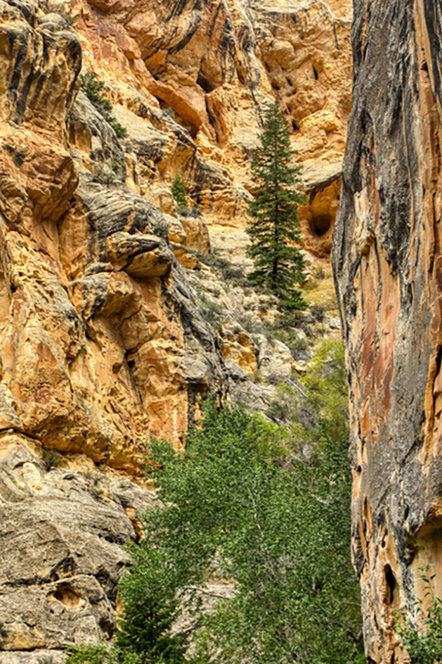 Gnarly Scene: A fir tree stands tall as it rises from the unique rocks that make up the canyon wall near Tower Rock. These twisted, folded and gnarly rocks allow viewers to gaze upon millions of years of geological activity in a single stop. The Sheep Creek was running low when we visited in August, but the green cottonwood trees and other foliage covered the canyon floor near the water supply. Photo by Gary Warren/ladailypost.com
 Grazing: As drivers near the end of the geological loop drivers pass some farms and ranches before returning to Highway 44. Cattle were grazing in a pasture land which was lined by various geological formations that are millions of years old. The contrast between the green grass and the colorful formations creates an interesting scene. Photo by Gary Warren/ladailypost.com
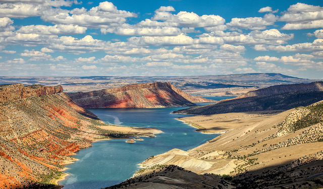 Sheep Creek Bay: Sheep Creek is one of many contributors to Flaming Gorge Reservoir. Seen is Sheep Creek Bay, which is a part of the long reservoir. This is near Wyoming and it is easy to visualize how the reservoir is opening up and becoming wider as it exits the canyons to the south. Photo by Gary Warren/ladailypost.com
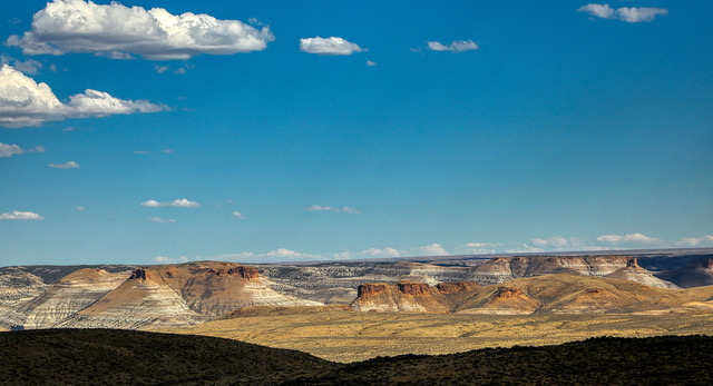 Flaming Gorge National Recreation Area: As the highway leads northward into Green River, Wyo., the mesas and landscape become much more arid and sparse. While not as scenic as some other areas in the Flaming Gorge area, it displays a unique beauty of its own as travelers gaze to the east, where the waters of the reservoir become visible. Photo by Gary Warren/ladailypost.com